
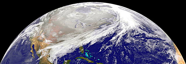
This NOAA GOES-East satellite image was captured at 1445 UTC/9:45 a.m. EST on January 28,
and between the clouds and the snow on the ground with cold air overhead, it appears as if much of the U.S. has been covered by an "Arctic Blanket." Arctic air has surged into the U.S. pushing into the Southeastern states and dropping high temperatures there into the 20s with colder wind chills. -- NASA Goddard / Satellite Shows an "Arctic Blanket" Over the U.S.
And that, folks, is what Winter looks like.
Posted by: Lazarus Long at January 28, 2014 7:02 PM
HOME